Data gives insights for food security, water management, and climate impacts
Wildfires, floods, tsunamis, earthquakes, and other natural disasters shape and reshape the face of the Earth in often unforeseen and incalculable ways.
But how will we know how the effects of future events will shape Earth’s landscapes?
SAIC works with NASA to develop systems that measure not only the impacts of oceanic, land, and atmospheric processes, but also how these processes affect day-to-day life. Using remotely sensed satellite data, these systems enable decision-makers to understand and manage things like water resource consumption, ecosystem preservation, humanitarian aid, sea level change, and erosion.
“As extreme weather events become more prolific, we want to know and, if possible, predict and manage the impacts of extreme weather and climate conditions on populations, especially in developing nations around the world,” said Bob Rosenberg, program manager for SAIC’s hydrological sciences support at NASA.
A grounded partnership
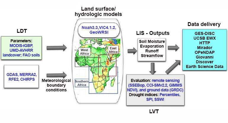
SAIC has worked with NASA’s Hydrological Sciences Laboratory (HSL) at Goddard Space Flight Center in Greenbelt, Maryland, for more than 20 years. One of the centerpieces of the HSL is the Land Information System (LIS), which incorporates different land surface models and uses the models to analyze historical data and new data as it is available in real time.
From these analyses, we can see how the land record changes over decades because of urbanization, deforestation, floods, fires, and other events that alter the topography and surface of the land.
Modeling the future
At the core of the LIS is data assimilation, which uses petabytes of historical data and multiple land surface models to generate analyses and forecasts. When more and better data sources are used in connection with the models, we have the potential to get highly accurate and detailed forecasts about the land surface and the atmosphere.
“By improving the accuracy of the input data, such as precipitation forcing data or the nature of a land surface, we get more accurate analyses and forecasts, which help decision makers understand the potential future of the environment around them,” Rosenberg said.
Using this data has also helped SAIC create indicators like drought indexes, which show, based on models and data inputs, how drought-stricken areas may continue or evolve, thus helping people understand and better manage water usage for drinking and irrigation.
Early red flags
This same technology is the backbone of the Famine Early Warning Systems Network (FEWS NET) hydrologic modeling and forecasting capabilities. FEWS NET is a unique program, created by USAID and including 7 domestic partners of which NASA is a major player. FEWS NET monitors conditions around the world, understands the warning signs of famine, and provides early warning to humanitarian organizations. FEWS NET’s partners at NASA use LIS/FLDAS, a decision support tool used to study how rainfall and water distribution over given land areas may or may not contribute to famine. It can help local agriculturists and farmers know how and where to plant crops year after year, rather than leaving it to their best guess. FEWS NET provides routine warnings for indications of approaching food insecurity based on data developed from the modeling systems and satellite measurements.
“As the climate continues to shift and trends change, more data helps these farmers be better prepared for each season,” Rosenberg said. “People in developing nations need to know if their crop that year is going to spoil or not, and if they’re going to be able to feed their populations.”
Continuously growing capabilities
We continue to investigate how emerging technologies, especially artificial intelligence and machine learning (AI/ML), can contribute to this important work. The LIS framework is already benefiting from AI/ML capabilities, allowing for more advanced incorporation of information from remote sensing.
With the help of government partners, SAIC is assisting with the operational delivery of a global soil moisture product via the U.S. Department of Agriculture Global Crop Production Decision Support System with NASA Soil Moisture Active Passive satellite observations. This will be another addition to our nation’s toolkit to forecast crop yields and provide data-based insights to farmers we rely on for our food supply.
Erosion, vegetation distribution, and natural disasters affect the Earth around us, and in turn, impact our way of life. We mitigate that by collating data from the past and present to understand and protect tomorrow’s environment.